skipped to
Departments
Bike Loan Program
In collaboration with LCLC and the Town of Bridgewater, we are launching a full bike loan program. We have the following bikes available (click the bike type for more details):
Where to borrow an e-bike:
Lunenburg County Lifestyle Centre (LCLC), 135 N Park St, Bridgewater
How to book:
- In person: LCLC Guest Services
- Phone: 902-530-4100
E-bike Eligibility:
- Ages 16+
- Ages 16–17 require parent/guardian co-signature
- Government issued ID number required for waiver form
pdf Frequently Asked Questions (Ebikes) (79 KB)
Same Day Pick ups and Returns
- Bikes must be booked at least one day in advance and are subject to availability.
- Bikes loans must be picked up and returned on the same day.
Loan Times
- Tuesdays: 10:30am – 4:30pm
- Wednesdays: 10:30am – 4:30pm
- Thursdays: 4:00pm – 6:00pm
Please note that the e-bikes are generally larger and heavier than standard bicycles and have wider tires. Because of their size, most standard bike racks are not suitable for transport.
We are excited to announce our partnership with Lunenburg County Wheels, who can assist with e-bike pick-ups and returns. To book a ride, please give them a call and mention that you are using their service for the e-bike loan program, and we will subsidize the ride fare! Contact Lunenburg County Wheels at 902-523-4455.
As the program grows, additional booking and pickup options may become available. Stay tuned on the District of Lunenburg Parks, Recreation & Tourism Facebook page for updates!
Dashboard
Volunteer Summit 2025

Winter Activities

- Rails to Trails Network
- MARC in Dayspring
- River Ridge Common in Pinehurst
- Miller Point Peace Park in Dayspring
- LaHave Sunset Park in Conquerall Bank

Water Recreation


LAKES:
- Wiles Lake Park in Wileville
- Molega Lake Park in Molega Lake
- Church Lake in Newburne
- Sucker Lake in Upper Northfield
- Mushamush Beach Park in Sweetland

OCEAN:
- United Communities Marine Park in Voglers Cove
- Sawpit Wharf Park in Garden Lots
- Hirtle’s Beach in Kingsburg
- Rose Bay Marine Park in Rose Bay
- Old Southeast Cove Wharf Day Park on Big Tancook Island
- Oakland Conservation Area in Oakland

RIVERS:
- LaHave Sunset Park in Conquerall Bank
- Miller Point Peace Park in Dayspring
- Petite Riviere Community Park in Petite Riviere

WATERFALLS:
- Indian Falls in Newburne
- Indian Brook Falls at River Ridge Common in Pinehurst
Play Parks, & Sports

- MARC Ballfields in Dayspring
- River Ridge Common in Pinehurst
Biking

- MARC in Dayspring
- River Ridge Common in Pinehurst
- Trails (multi use)
- Miller Point Peace Park in Dayspring
- Indian Point Rest Stop in Indian Point
Hiking / Walking

- Indian Path Common in Indian Path
- Indian Falls, Newburne
- MARC in Dayspring
- Miller Point Peace Park in Dayspring
- River Ridge Common in Pinehurst
- Arthur Young Trail in Cookville
- Gaff Point at Hirtles Beach in Kingsburg
- Trails (multi-use)
- Geocache Challenge
- District of Lunenburg Hike/Hike Nova Scotia Challenge

Coastal Protection
Coastal protection regulations are now in effect in the Municipality of the District of Lunenburg. On June 18, 2024, Council passed the Second Reading to amend MODL’s Municipal Planning Strategy and introduce a new Municipal-Wide Land Use By-law that includes coastal protection regulations. These changes were approved by the Minister of Municipal Affairs and Housing on August 9, 2024. The regulations aim to protect coastal development from the effects of climate change and to protect the coastline from human development by addressing concerns such as coastal erosion, flooding, and the preservation of sensitive ecosystems.
If a development is proposed within the Designated Coastal Protection Area (see the Coastal Development Permit Area on the Zoning Map), it is subject to the regulations of the Municipal-Wide Land Use By-law.
pdf Municipal Planning Strategy Cluster Development(449 KB)
pdf Municipal Wide Land Use By law Cluster Development(321 KB)
Coastal Protection Regulations Summary
The Land Use By-law primarily identifies development setbacks that are tied to different areas within the Designated Coastal Protection Area.
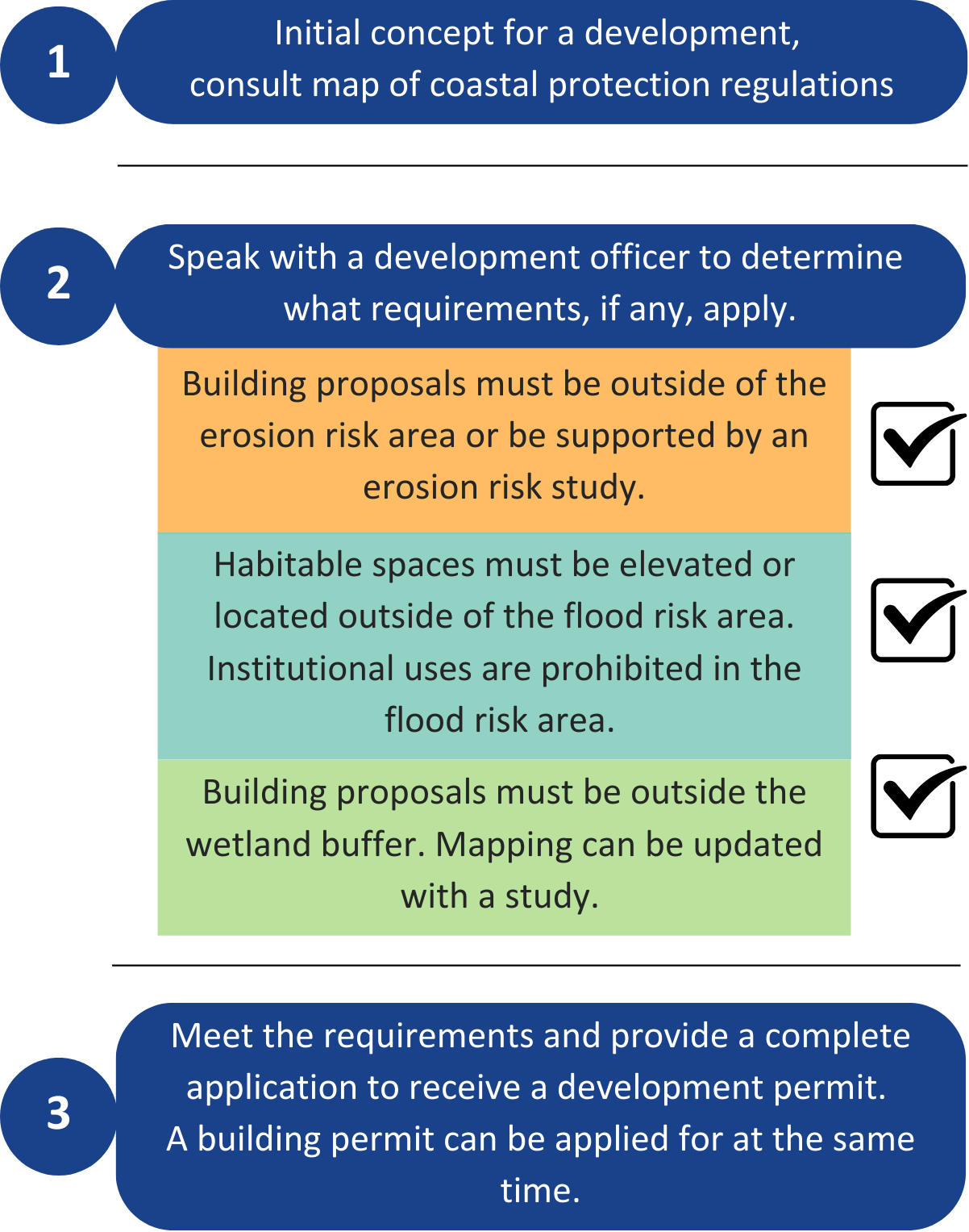
Erosion Risk Area: The Coastal Erosion Risk Area is designed to protect properties from erosion and preserve ecosystems. Development cannot occur within 30 m from the top of the bank or the ordinary high watermark if the bank is indiscernible. No natural vegetation may be removed within 15m from the top of the bank or the ordinary high watermark.
Flood Risk Area: The Flood Risk Area identifies coastal regions most vulnerable to flooding from tides, sea level rise, and storm surge, projecting total inundation by 2100. No buildings in these areas can have habitable spaces below 3.97m of CGVD 2013. Institutional uses are strictly prohibited within the Coastal Flood Risk Area, regardless of elevation.
Wetlands: Development within 30 metres of Coastal Wetlands is prohibited.
Looking to develop or renovate near the Coast? Take a look at the flow chart below to understand potential next steps:
For more information about how the regulations came to be, please visit Engage MODL.
Coastal Erosion Risk Factor Assessment (CERFA)
Section 4.14.1 of the Land Use By-law requires a 30-metre horizontal setback from the top of the bank for new development. However, Section 4.14.5 of the Land Use By-law allows for a reduction in the setback, down to a minimum of 15 metres, only if a Coastal Erosion Risk Factor Assessment (CERFA) demonstrates that the erosion rate is slower than the planning horizon of 77 years.
The Municipal Guidelines document provides an overview of what must be included when submitting a CERFA to the municipality. The Technical Background and Guidance document is the full report.
CERFA Technical Background and Guidance
What is Planning?
Planning is the act of managing land uses in the present and into the future to help shape sustainable, equitable, and innovative communities. In a municipality, land use is guided by planning strategies and by-laws.
Municipal Planning Strategy
A municipal planning strategy guides the development and management of a Municipality. The municipal planning strategy has the long-term vision of community, sets the guiding principles on a variety of sectors, and is written in general terms. To further this purpose, the municipal planning strategy establishes:
1. policies which address problems and opportunities concerning the land development and the effects of the development;
2. policies to provide a framework for the environmental, social, and economic development within the Municipality;
3. policies that are consistent with the provincial interest on drinking water protection, agricultural land conservation, flood risk mitigation, infrastructure management, and housing promotion; and
4. specify actions necessary for implementing the municipal planning strategy.
Secondary Planning Strategy
Secondary planning strategies are supplementary to a municipal planning strategy and pertain to a specific community or topic within a municipality.
Land Use By-law
A land use by-law expands on the policy statements in a planning strategy. It is written in more detail and definitive terms so there is a clear understanding of what you can and cannot do with your lands. Land use by-laws typically identify zones that encourage certain land uses (e.g., residential, commercial, etc.). By-laws state one or more of the following for each zone:
- Lot area and frontage requirements;
- The location, size, and height of structures;
- Permitted signage, outdoor storage, parking;
- Erosion control standards such as setback from watercourses.
More Articles ...
- Tax Installment Prepayment Plan Enrollment Form
- Tax Installment Prepayment Plan (TIPP) - Change or Cancel TIPP Request Form
- PRO Fund
- Community Engagement
- Energy Efficient Homes and Buildings
- Climate Change and Sustainability
- Roof-mounted Solar Panels
- Short-term Rentals
- Application for a Building, Development or Demolition Permit
- Flood Risk
- Oakland Conservation Area
- Indian Point Rest Stop